This week marks 50 years since Orbost’s most damaging flood ripped through the town.
The February floods of 1971 will live long in the memory of those who saw them, while this article will break down what those people faced at the time.
Ten bridges ranging in length from 30 feet to 200 feet were washed away and 40 culverts (two to six feet in diameter) were washed out.
That was the preliminary estimate of losses sustained in the Orbost shire as a result of the devastating floods.
The floods caused tremendous damage to roads and structures on highways, incalculable for the then Orbost Shire.
The report read:
Marlo Road: Three large washouts including the new gulch adjacent to the Snowy Bridge.
Bituminous surfacing stripped off in sections throughout the whole length of road. Debris and trees along road reserve and damage to the river bank. Marlo jetty demolished.
“B” Road: Washout at north end completely cutting off the road. Trees and debris throughout, silt and sand deposits.
Jarrahmond Road: Collapsed culvert. Loss of surface gravel at north end.
Huxters Road: Large washout near flood gates completely across roadway.
Buchan Road: Ashby’s Gulch: Deep washout across sealed road. Slips adjacent to river at Bete Bolong. Culvert collapsed at Telephone Gully.
Lochend Road: Large washout on edge of sealed road. Silt and sand deposits.
Orbost Camping Park: Severe damage to horticulture. All roads stripped. Fence demolished.
Combienbar Road: 2000’ of roadway stripped of gravel (recently prepared for sealing). Four side slips into river between Errinundra bridge and the ‘Tin Hut’. These will require major construction with steep side cutting into rock to provide adequate road widths.
Clay’s Bridge: 35’ span demolished – will require new piled pier and 45’ span.
Henleigh’s Creek: New pier required and creek has cut a new course beyond the bridge, 60’ wide and 12’ deep (requires new spans or redirect creek). Fifty-four-inch diameter culvert demolished. Pipes may be recoverable. Two further culverts washed out, 24” and 18” diameter. Farmers bridge demolished, provide access approximately 140’ long Clay’s Bridge, Chester’s Bridge (?), thought beyond repair.
Errinundra Road: Washouts beyond Ada River bridge. Culverts slumped.
West Cann Bridge: Approaches to both sides washed away (40’ – 60’ respectively). Temporary bridges are being constructed over gaps. Two culvert washouts.
Tamboon Road: Several washouts.
Everard Road: Severe washouts for 200 yards beyond first Thurra Bridge. Second Thurra bridge completely demolished. This would be the largest bridge lost so far.
Wangrabelle Road: Fourteen culverts washed out (sizes vary from 15” pipe to 3’ diameter pipe and up to 5’x4’ timber culverts). Severe erosion throughout. Both abutments to this bridge over Wangrabelle Creek have been washed out and remaining structures very weak. Temples culvert will require a large structure. Gully now 40’ wide and 10’ deep.
Genoa Camp Park: Toilet block demolished. Craigie Bog Road: Bridge demolished. Tubbut Area: Two access bridges over
Deddick River have lost their approaches. Further damage expected when detailed inspection is complete.
Moresford Road: Culverts washed out in several localities. Several erosions on steep sections.
The Snowy River Mail reported on the floods with these articles.
SNOWY RIVER BARES ITS TEETH
Desolation and destruction followed in the wake of a major flood - a record in the history of Orbost and district - which over last weekend, claimed the life of a well-known townsman, caused the loss of many hundreds of head of stock, ruined bean and sweet corn crops and pastures, destroyed miles of fencing, washed out roads and culverts, swept away bridges and caused a subsidence in the Orbost end of the Snowy River bridge and covered many square miles of the rich, fertile Jarrahmond and Orbost river flats, besides disrupting telephone, rail services and the electric power supply - in fact, within the space of a few hours, practically turning the district into a disaster area.
The same picture prevailed in other parts of the shire when the Cann and Genoa rivers, and other streams, rose rapidly, covered to surrounding farm lands, and left a trail of destruction as the waters made their mad dash to the sea.
Some faint idea of the turbulence of the Snowy in one of its angriest moods, may be gleaned as the water recedes from the river flats, where mud, silt and debris covers miles of what were once lush pastures and crops (almost to splendid maturity) making an awe inspiring picture tinged with a great deal of sadness for those that suffered from the river’s wrath.
“IT’S ALL GONE. WE’VE JUST BEEN OUT TO THE FARM BY BOAT. THERE IS NOTHING LEFT – IT’S ALL GONE.”
Pathetic statements such as this were heard all too often as landholders and farmers checked in to the Orbost Police Station on Sunday morning just to notify police of their safe return.
The full extent of the destructive power of the Snowy in flood was only beginning to be realised, for the day before, February 6th, the river at Orbost had risen to an all time record of 33 feet.
During the Saturday, reports on the hour were received from Amey’s 20 miles upstream, by Mr Don McKenzie, Snowy River Improvement Trust secretary, and relayed to police and farmers.
These readings gradually rose, at first by six to seven feet an hour, and climbed to an unbelievable 50ft 8”.
With about three to four hours travelling time from Amey’s to Orbost, farmers had little chance of rescuing stock and belongings.
Realising the enormity of the coming disaster, police and ambulance men swung into action and a helicopter under charter to Esso in Bass Strait was supplied for evacuation.
All day Saturday morning the aircraft was used for this purpose and was a great assistance to those marooned by flood waters.
The surf rescue boat from Lakes Entrance also rescued many people and was a familiar sight on the swollen river.
The craft suffered damage when a large branch went into the turbine of the jet engine.
Repairs were effected and the craft and its crew of four returned to Lakes yesterday.
300 EVACUATED
Almost 300 people were evacuated from the Snowy River flats area and billeted with friends in Orbost.
In response to an appeal for beds for the homeless, almost 200 offers of accommodation from Orbost residents were received by police. Many of these were not required.
TRAGEDY STRIKES
One of the saddest aspects of the weekend toll of destruction was the reported missing of a well-known townsman, Mr Robert F. Greenwood.
Orbost Police stated that Mr Greenwood is missing following a boating accident at 6am on Sunday morning 7th.
It appears that Mr. Greenwood’s cabin cruiser “Audrey-G” had broken away from its mornings.
In an attempt to row across to rescue the boat, Mr Greenwood was capsized into the swirling flood waters.
It is thought he may not have realised that the Snowy River had cut another entrance and was flowing at such a speed. The boat he was rowing and the “Audrey-G”
have since been picked up by trawlers and taken to Lakes Entrance in good order.
Boats belonging to Harold Sederlan and Bill Jones have also been rescued and taken to Lakes Entrance.
The missing Mr Robert F. Greenwood is aged 49 years and a native of Metung.
In his younger days he was a sportsman of renown in cricket, football and tennis.
When 19 years old he entered and served with 2/22 in New Guinea.
His mother lives in Bairnsdale and his wife and son Robert, and daughter Jo-Anne at Orbost.
SNOWY CHANGES COURSE
This is the opinion of Mr Ross Walcott, of Orbost, when interviewed by a Snowy River Mail rep. following a survey of the flooded farm lands of the Jarrahmond flats on Monday last.
He said that Mr Nigel Mundy’s farm at Bete Bolong is surrounded by about three feet of pure white sand.
The course of the Snowy is then through Mr George Hodges’ former bean paddock and into Mr Clyde Lynn’s paddock.
The river runs straight, said Mr Walcott, and goes right down to Mr Ivan Trewin’s property, much of which was washed away and a terrific amount of land lost.
At Jarrahmond, said Mr Walcott, the destruction to Messrs D & R Pardew’s and Mr P C (Toby) Nixon’s dairies is frightening to see.
There is an estimated three feet of sand everywhere, with a tremendous amount of timber debris lying in every direction.
To bring all this land back into production will mean an awful lot of money and hard work, he said.
The dairy and machinery shed on Mr Toby Nixon’s property (share farmed by Mr M Collett) were washed away whilst the bank which ran behind these and Pardew’s dairy has disappeared.
Many of the dairy cattle on the Nixon property were washed away by the raging torrent, but a
number have since been found as far away as Marlo.
It is thought that a lot of cattle now missing will later turn up and the losses may not be as serious as at first expected.
Mr Walcott thought among the biggest losers of cattle were Mr PC Nixon’s dairy herd, Messrs Elliot and John Pardew’s 100 odd beef bullocks, cows and calves, Mrs C Hammill’s (Jarrahmond) cows. Of the latter, some have been rescued from willow trees.
All photos unless stated are from the Orbost and District Historical Society collections and have been collated and presented by member, Carrol Preston, for the Snowy River Mail.
IMAGE:
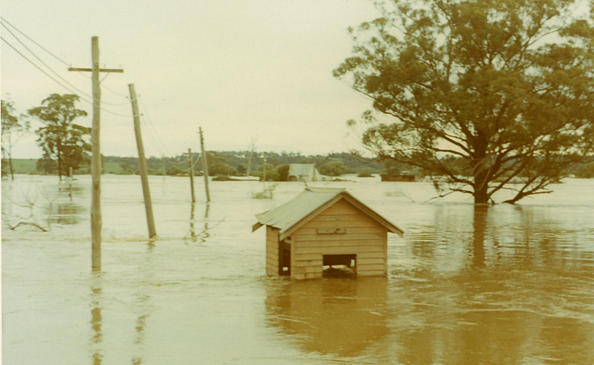
Orbost Pump House, situated near the Butter Factory on the corner of Forest Road and Clarke Street, had stood stalwart measuring the level of this most recent flood.